

Walks around Mevagissey
Enjoy the walks by being guided by the app


-
3.2 miles/5.2 km - Easy
King's Wood and Pentewan Valley

King's Wood and Pentewan Valley
3.2 miles/5.2 km - Easy
A circular walk through the King's Wood Woodland Trust reserve to the lost port of Pentewan, along the trackbed of the horse-drawn tramway that once carried china clay to the busy port and via the system of reservoirs and sluices that were used to flush sand out of the harbour.
-
3.4 miles/5.4 km - Moderate
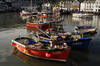
Mevagissey to Portmellon

Mevagissey to Portmellon
3.4 miles/5.4 km - Moderate
A circular walk from the busy fishing port of Mevagissey into the Portmellon Valley and through the West Bodrugan Woods nature reserve to the beachside village of Portmellon where boats have been built for hundreds of years, and still are.
-
4.9 miles/7.9 km - Moderate
Gorran Haven to Dodman Point

Gorran Haven to Dodman Point
4.9 miles/7.9 km - Moderate
A circular walk in the bays of Mevagissey and Veryan from the fishing village of Gorran Haven to the remote, sandy Hemmick Beach via The Deadman's Point of old nautical maps, still marked with a huge cross to warn sailors of the perilous lee shores, and Vault Beach where the wreckage washed ashore.
-
5.9 miles/9.6 km - Moderate
Gorran Haven to Portmellon

Gorran Haven to Portmellon
5.9 miles/9.6 km - Moderate
A circular walk from Gorran Haven to Portmellon via the sheer cliffs from which Henry Bodrugan leapt to escape execution and sheltered Colona Beach, returning through West Bodrugan Woods Nature Reserve and via Gorran church which now has some of the finest bells in the country.
-
3.8 miles/6.1 km - Moderate-strenuous
Caerhays Castle to Hemmick Beach

Caerhays Castle to Hemmick Beach
3.8 miles/6.1 km - Moderate-strenuous
A circular walk around Veryan Bay between two sandy beaches from Caerhays Castle where the gardens contain nationally-important collections from the expeditions of Victorian plant hunters
-
5.3 miles/8.5 km - Moderate-strenuous
Pentewan, Heligan and Mevagissey

Pentewan, Heligan and Mevagissey
5.3 miles/8.5 km - Moderate-strenuous
A circular walk from Pentewan to Mevagissey via The Lost Gardens of Heligan which were discovered in the 1990s after 7 decades of neglect and what followed The Times described as the garden restoration of the century.
-
7.6 miles/12.3 km - Moderate-strenuous
Mevagissey to Charlestown (via bus)

Mevagissey to Charlestown (via bus)
7.6 miles/12.3 km - Moderate-strenuous
A one-way coastal walk, made circular via an initial bus journey, from the fishing port of Mevagissey to Charlestown - one of the best-preserved Georgian ports in the world and an engineering masterpiece which included a seven-mile-long leat.
-
6.6 miles/10.6 km - Strenuous
Pentewan Valley and Black Head

Pentewan Valley and Black Head
6.6 miles/10.6 km - Strenuous
A circular walk from the lost port of Pentewan along the coast to the remains of the Iron Age fort overlooking St Austell Bay on Black Head, returning via the nature reserve that was once the King's wood and the trackbed of the horse-drawn tramway used for china clay and Sunday School outings.


Download the iWalk Cornwall app and use the QR scanner within the app to find out more about any of the walks above.
For a walk which includes Mevagissey Harbour, there's Mevagissey to Portmellon. Circular walks covering some of the coastline towards Dodman Point include Gorran Haven to Portmellon and Gorran Haven to Dodman Point. In the other direction, towards St Austell Bay, there is a Pentewan Valley and Black Head circular walk.
