

Walks in Cornwall with mining/quarrying heritage
Enjoy the walks by being guided by the app


The walks cover areas with metalliferous mining and also the major slate quarrying areas including Delabole and the coastal quarries around Tintagel.
-
2.2 miles/3.6 km - Easy
Eden Project

Eden Project
2.2 miles/3.6 km - Easy
A walk though a granite landscape mined first for tin, then china clay and now for geothermal power to generate electricity and heat the space-age greenhouses of the Eden Project.
-
2.5 miles/4 km - Easy
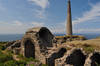
Botallack Head

Botallack Head
2.5 miles/4 km - Easy
A circular walk around Cornwall's most iconic mining remains, used for the filming of the BBC's Poldark series
-
2.7 miles/4.3 km - Easy
Hayle and The Towans

Hayle and The Towans
2.7 miles/4.3 km - Easy
A circular walk on the Towans at Hayle, where Cornwall's beam engines were cast using sand from a prehistoric lagoon when West Penwith was an island.
-
6 miles/9.6 km - Easy
Twelveheads and Chacewater

Twelveheads and Chacewater
6 miles/9.6 km - Easy
A circular walk in the Copper Kingdom of the Old World where the majority of world's copper came from during the 18th and 19th Centuries
-
2.4 miles/3.8 km - Easy-moderate
Gwithian and Upton Towans

Gwithian and Upton Towans
2.4 miles/3.8 km - Easy-moderate
A circular walk around the nature reserve in the sand dunes that was once the National Explosives Works where young girls manufactured dynamite from nitroglycerine, two tonnes of which detonated causing a shock wave that broke windows in St Ives and Penzance and could be heard on Dartmoor.
-
2.4 miles/3.9 km - Easy-moderate
Tintagel, Church and Castle

Tintagel, Church and Castle
2.4 miles/3.9 km - Easy-moderate
A short circular walk exploring some of the historic sites in Tintagel including King Arthur's Castle and Merlin's Cave, the Old Post Office, and the ancient parish church on the cliffs.
-
2.7 miles/4.4 km - Easy-moderate
Gwennap Pit to Carn Marth (short version)

Gwennap Pit to Carn Marth (short version)
2.7 miles/4.4 km - Easy-moderate
A circular walk at Carn Marth with panoramic views right across mid-Cornwall to Falmouth and the Roseland, the Cornish Alps and Bodmin Moor, and St Agnes and Trevose Head
-
3 miles/4.9 km - Easy-moderate
Baker's Pit and Rogers' Tower

Baker's Pit and Rogers' Tower
3 miles/4.9 km - Easy-moderate
A circular walk from the Bakers Pit nature reserve to an Iron Age hillfort where the remains of prehistoric roundhouses were seen as a convenient source of stone for a folly built in the era when the Poldark novels are set.
-
3.0 miles/4.9 km - Easy-moderate
St Agnes Beacon and Wheal Coates

St Agnes Beacon and Wheal Coates
3.0 miles/4.9 km - Easy-moderate
A circular walk between St Agnes Head and the engine houses of Wheal Coates via St Agnes Beacon, with spectacular panoramic views
-
3 miles/4.8 km - Easy-moderate
Tintagel Church to Trebarwith Strand

Tintagel Church to Trebarwith Strand
3 miles/4.8 km - Easy-moderate
A circular walk on quarrymens' trails along the cliffs of Tintagel past the Thunderhole blowhole to the long, sandy beach at Trebarwith Strand from Tintagel's mediaeval clifftop church with relics including the font that once stood in Tintagel Castle's chapel.
-
3.4 miles/5.5 km - Easy-moderate
Luxulyan Valley circular

Luxulyan Valley circular
3.4 miles/5.5 km - Easy-moderate
A circular walk following the leats and horse-drawn tramways through the World Heritage site of the Luxulyan Valley to the massive viaduct which carried the tramways towards Newquay and water to winch the trams up the valley with a huge waterwheel, recommended in guidebooks as early as the 1920s "as one of the most glorious walks in all Cornwall".
-
3.4 miles/5.4 km - Easy-moderate
Wheal Maid and Poldice Valley

Wheal Maid and Poldice Valley
3.4 miles/5.4 km - Easy-moderate
A circular walk in the area described in Victorian times as the richest square mile anywhere on Earth
-
3.7 miles/6.0 km - Easy-moderate
Calstock

Calstock
3.7 miles/6.0 km - Easy-moderate
A walk at Calstock where a Victorian mineral railway from Kelly Bray once ran down to the quayside and the viaduct was built in the 1900s to connect this to Plymouth, creating today's Tamar Valley Line. The walk includes an option circular diversion around the relics of Okel Tor mine.
-
5 miles/8 km - Easy-moderate
Minions and Caradon Hill

Minions and Caradon Hill
5 miles/8 km - Easy-moderate
A walk through the remains of the UK's most productive copper mines which employed thousands of people in Victorian times, including brakemen who each scooted an individual loaded ore wagon down to Liskeard on the railway that forms much of the walk route.
-
5 miles/8 km - Easy-moderate
St Austell, Clay Trails and Menacuddle Well

St Austell, Clay Trails and Menacuddle Well
5 miles/8 km - Easy-moderate
A circular walk in china clay country, including a trail laid on the trackbed of a mineral railway from St Austell to the Cornish Alps and one of Cornwall's most picturesque holy wells.
-
5.8 miles/9.3 km - Easy-moderate
St Stephen and Tregargus Valley

St Stephen and Tregargus Valley
5.8 miles/9.3 km - Easy-moderate
A circular walk from St Stephen along a tributary valley of the River Fal to the hamlet of Coombe via some of Cornwall's best preserved remains of the Victorian and early 20th Century China Stone industry
-
6 miles/9.6 km - Easy-moderate
Stithians to Kennall Vale

Stithians to Kennall Vale
6 miles/9.6 km - Easy-moderate
A circular walk in the valley of the River Kennall, where during Victorian times the cascading river was used to power gunpowder mills, five of which exploded in a chain reaction so violent that the roof of one was found a mile away.
-
6.1 miles/9.8 km - Easy-moderate
Feock to Devoran

Feock to Devoran
6.1 miles/9.8 km - Easy-moderate
A circular walk to the Victorian-engineered town of Devoran which was once the largest mining port in Cornwall, and along Restronguet Creek on the route of the railway that lead from the ore bins and smelting houses to the mines of Redruth
-
6.2 miles/10 km - Easy-moderate
Gwennap Pit and Carn Marth

Gwennap Pit and Carn Marth
6.2 miles/10 km - Easy-moderate
A circular walk through an area steeped in mining history, with panoramic views from Carn Marth and the almost legendary Gwennap Pit which became so famous that even the neighbouring mine was renamed to Cathedral
-
2.5 miles/4 km - Moderate
Danescombe Valley

Danescombe Valley
2.5 miles/4 km - Moderate
A circular walk from Cotehele Quay into the broadleaf woodland of the Danescombe Valley where bluebells and orchids flower in spring and fungi erupt through the carpet of autumn leaves.
-
3.1 miles/4.9 km - Moderate
Trevaunance Cove and Blue Hills mine

Trevaunance Cove and Blue Hills mine
3.1 miles/4.9 km - Moderate
A circular walk along the stream of Trevellas Coombe where tin ore is still worked using traditional water power, past Stippy Stappy - the row of sea captain's cottages, and down the valley to the sandy beach of Trevaunance Cove with the remains of Victorian harbour which was demolished by Atlantic storms.
-
3.6 miles/5.8 km - Moderate
Delabole

Delabole
3.6 miles/5.8 km - Moderate
A circular walk around Delabole past the slate quarry, along back lanes and tracks, and through fields and bluebell woods. The route circles the quarry pit and passes the showroom from which tours are available.
-
3.8 miles/6.8 km - Moderate
Minions and the Cheesewring

Minions and the Cheesewring
3.8 miles/6.8 km - Moderate
A circular walk around the iconic landmarks at Minions, including The Hurlers stone circles, The Cheesewring and the engine houses of the South Phoenix Mine.
-
4.0 miles/6.5 km - Moderate
Pendeen to Portheras Cove

Pendeen to Portheras Cove
4.0 miles/6.5 km - Moderate
A circular walk from Pendeen via the Geevor and Levant mines to the lighthouse at Pendeen Watch, returning via the white, sandy beach at Portheras Cove.
-
4.2 miles/6.7 km - Moderate
The Rumps to Polzeath around Pentire Point

The Rumps to Polzeath around Pentire Point
4.2 miles/6.7 km - Moderate
A circular walk across the Iron Age hillfort on the twin headlands of The Rumps and around Pentire Point, with panoramic views of the Camel Estuary and the offshore islands, to the sandy beach at Polzeath. The Pentireglaze lead mine extends from the headland beneath the sea and boats could be heard passing overhead from within the tunnels.
-
4.4 miles/7 km - Moderate
Praa Sands to Trewavas Mine

Praa Sands to Trewavas Mine
4.4 miles/7 km - Moderate
A circular walk from Praa sands across Rinsey Head to the engine house of the ironically-named Wheal Prosper, and Trewavas mine where an engine house now forms part of the path
-
4.7 miles/7.5 km - Moderate
Perranporth to St Agnes (via bus)

Perranporth to St Agnes (via bus)
4.7 miles/7.5 km - Moderate
A one-way coastal walk, made circular via an initial bus journey, along the ore-bearing cliffs between Perranporth and St Agnes passing the remains of Nobel's dynamite works, Britain's best preserved spitfire base and the Blue Hills of Trevellas Coombe where tin is still processed on a small scale using traditional methods.
-
4.7 miles/7.5 km - Moderate
Porthtowan to Chapel Porth

Porthtowan to Chapel Porth
4.7 miles/7.5 km - Moderate
A circular walk from Porthtowan, along the coast, valleys and woodland, passing engine houses and other relics of Cornish copper mining.
-
4.8 miles/7.8 km - Moderate
Godolphin to Tregonning

Godolphin to Tregonning
4.8 miles/7.8 km - Moderate
A circular walk from the mansion with possibly the oldest formal gardens in the country to two hills that altered the course of history, creating the wealthiest estate in Cornwall and giving rise to the Cornish China Clay industry.
-
4.8 miles/7.8 km - Moderate
Luxulyan Valley to Prideaux

Luxulyan Valley to Prideaux
4.8 miles/7.8 km - Moderate
A circular walk through the World Heritage site of the Luxulyan Valley and surrounding countryside, over the massive viaduct supporting a horse-drawn tram route to Newquay and along the leat that fed Charlestown Harbour.
-
5 miles/8 km - Moderate
Caradon Hill to Trethevy Quoit

Caradon Hill to Trethevy Quoit
5 miles/8 km - Moderate
A circular walk in the valley of the River Seaton to the Neolithic tomb from the copper mines of Caradon Hill where the brittle ore could not be usefully crushed by machine so teenage girls were used instead to break the ore with hammers.
-
5 miles/8 km - Moderate
Trebarwith Strand to Tintagel Castle

Trebarwith Strand to Tintagel Castle
5 miles/8 km - Moderate
A walk on the tracks trodden by the donkeys laden with slate from the coastal quarries of Trebarwith to Tintagel Haven where the slate was loaded onto ships and Tintagel Castle's island, inhabited during the mediaeval period, the Celtic times of King Arthur, and before this by the Romans.
-
5.3 miles/8.5 km - Moderate
Callestick and Ventongimps

Callestick and Ventongimps
5.3 miles/8.5 km - Moderate
A circular countryside walk past the nature reserve at Ventongimps and the engine house of West Chyverton mine, with refreshment opportunities at both Callestick Farm, where you can see the ice cream being made, and Healey's Cyder Farm who offer tours and tasting.
-
5.3 miles/8.6 km - Moderate
Kit Hill to Kelly Bray

Kit Hill to Kelly Bray
5.3 miles/8.6 km - Moderate
A circular walk in Kit Hill Country Park, given to the county by the Duchy to mark the birth of Prince William and where a midsummer bonfire is lit to celebrate the ancient Celtic Golowan festival
-
5.4 miles/8.6 km - Moderate
Cape Cornwall to Levant

Cape Cornwall to Levant
5.4 miles/8.6 km - Moderate
A circular walk from England's only Cape, via the engine houses of Kenidjack Valley and perched on rock ledges at Botallack Head, to Levant Mine which had over 60 miles of tunnels beneath the Atlantic and now has a working restored beam engine.
-
5.4 miles/8.7 km - Moderate
Perranporth to Trevellas

Perranporth to Trevellas
5.4 miles/8.7 km - Moderate
A circular walk past the remains of Alfred Nobel's dynamite works to the red-and-yellow ore-rich cliffs above the wreck of the treasure ship Hanover, returning, via the spitfire base, along Perran Coombe where a 2-mile leat once carried water to power a massive waterwheel in a chamber within the cliffs.
-
5.5 miles/8.7 km - Moderate
Boscastle to Tintagel (via bus)

Boscastle to Tintagel (via bus)
5.5 miles/8.7 km - Moderate
A one-way coastal walk, made circular via an initial bus journey, along the dramatic coastline of islands and arches from Boscastle to Tintagel, rated as one of the top five walks in Cornwall. The route includes the most northerly of the coastal slate quarries where trilobite fossils could occasionally be found in the slate tips.
-
5.6 miles/9 km - Moderate
Delabole to Lanteglos

Delabole to Lanteglos
5.6 miles/9 km - Moderate
A circular walk through bluebell woodland, fields and along back lanes from Delabole to Camelford's parish church at Lanteglos, returning via the Iron Age forts of Castle Goff and Delinuth Camp. The route passes around the edge of Delabole quarry and ends at the showroom from which tours are available.
-
5.9 miles/9.5 km - Moderate
Carn Brea and the Great Flat Lode

Carn Brea and the Great Flat Lode
5.9 miles/9.5 km - Moderate
A circular walk along the Great Flat Lode, where the Basset family made their fortune from the rich mineral reserves, to Carn Brea where they built a hunting lodge balanced on a tor in the style of a castle.
-
5.9 miles/9.5 km - Moderate
Cotehele to Calstock

Cotehele to Calstock
5.9 miles/9.5 km - Moderate
A circular walk through the gardens of Cotehele to Calstock where Cornwall's largest Roman fort once stood, the Vikings allied with the Cornish to fight off the Saxons, and more recently railway wagons were lifted over 100ft by steam power from the quay to the top of the viaduct. The walk includes an option circular diversion around the relics of Okel Tor mine.
-
6.2 miles/10 km - Moderate
Chapel Porth to Trevaunance Cove

Chapel Porth to Trevaunance Cove
6.2 miles/10 km - Moderate
A circular walk along the coast between the golden sandy beaches of Chapel Porth and Trevaunance Cove at St Agnes via the iconic engine houses of Wheal Coates, perched above the breakers.
-
6.2 miles/9.9 km - Moderate
Par and St Blazey
Par and St Blazey
6.2 miles/9.9 km - Moderate
A circular walk at Par where the land itself was created by the mining industry and is being re-sculpted by nature into sandy beaches, streams and woodland.
-
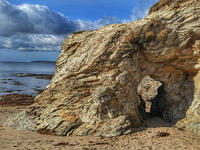
2.2 miles/3.5 km - Moderate-strenuous
Trebarwith Strand to Backways Cove

Trebarwith Strand to Backways Cove
2.2 miles/3.5 km - Moderate-strenuous
A short circular walk from the long, sandy beach of Trebarwith Strand to the rugged rocky cove at Backways in which sea foam tornadoes form in windy weather, and returning over the massive headland of Dennis Point with panoramic views of Port Isaac Bay. The cove has been shaped by coastal slate quarrying and the tramways are still evident.
-
4.5 miles/7.2 km - Moderate-strenuous
Gunnislake to Chilsworthy

Gunnislake to Chilsworthy
4.5 miles/7.2 km - Moderate-strenuous
A circular walk in the Tamar Valley at Gunnislake where Victorian canal systems, engine houses and tramways have been recolonised by nature and kingfishers rather than barges now journey up and down the river.
-
5.2 miles/8.4 km - Moderate-strenuous
Portreath and Tehidy Woods

Portreath and Tehidy Woods
5.2 miles/8.4 km - Moderate-strenuous
A circular walk along the rugged North Cliffs hiding smuggler's coves such as Ralph's Cupboard, to the sandy beach and historic mining port of Portreath, returning via the bluebell woodland of Illogan and Tehidy Country Park.
-
5.5 miles/8.8 km - Moderate-strenuous
Carn Galver to Mên-an-Tol

Carn Galver to Mên-an-Tol
5.5 miles/8.8 km - Moderate-strenuous
A circular walk from the coast to the highest area of moor on West Penwith passing engine houses and prehistoric monuments and with spectacular heather in late summer
-
6.8 miles/10.9 km - Moderate-strenuous
Porthleven to Rinsey Head

Porthleven to Rinsey Head
6.8 miles/10.9 km - Moderate-strenuous
A circular walk from Porthleven to the cliff-edge engine houses of Rinsey Head and Trewavas where the under-sea mine, set out with tables and food for the annual Tribute dinner, is said to have been breached by the sea just minutes before all the miners were due underground.
-
7.6 miles/12.3 km - Moderate-strenuous
Mevagissey to Charlestown (via bus)

Mevagissey to Charlestown (via bus)
7.6 miles/12.3 km - Moderate-strenuous
A one-way coastal walk, made circular via an initial bus journey, from the fishing port of Mevagissey to Charlestown - one of the best-preserved Georgian ports in the world and an engineering masterpiece which included a seven-mile-long leat.
-
7.3 miles/11.7 km - Strenuous
Portreath to Tobban Horse

Portreath to Tobban Horse
7.3 miles/11.7 km - Strenuous
A circular walk along the rugged coast from Portreath towards Porthtowan passing small coves and remnants of the clifftop mines beside the old RAF base, and returning via the horse-drawn tramway that brought fortune to Portreath harbour, where its "lighthouse" and "monkey house" remain from the shipping activity.
-
9.7 miles/15.6 km - Strenuous
Port Isaac to Tintagel

Port Isaac to Tintagel
9.7 miles/15.6 km - Strenuous
A one-way walk from Port Isaac to Tintagel along towering cliffs, past the long, sandy beaches of Tregardock and Trebarwith, the slate pinnacles of the coastal quarries and via the mediaeval cliff-top church to the castle of Arthurian legend.


Download the iWalk Cornwall app and use the QR scanner within the app to find out more about any of the walks above.
