

Circular walks around Fowey
Enjoy the walks by being guided by the app


-
2.2 miles/3.6 km - Easy
Eden Project

Eden Project
2.2 miles/3.6 km - Easy
A walk though a granite landscape mined first for tin, then china clay and now for geothermal power to generate electricity and heat the space-age greenhouses of the Eden Project.
-
3.5 miles/5.6 km - Easy
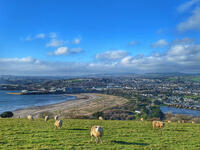
Par and Tywardreath

Par and Tywardreath
3.5 miles/5.6 km - Easy
A circular walk at Tywardreath where a mediaeval Priory was based and Par where much of the route was once a tidal creek and a wetland nature reserve has been created on some of the reclaimed land.
-
3.4 miles/5.5 km - Easy-moderate
Luxulyan Valley circular

Luxulyan Valley circular
3.4 miles/5.5 km - Easy-moderate
A circular walk following the leats and horse-drawn tramways through the World Heritage site of the Luxulyan Valley to the massive viaduct which carried the tramways towards Newquay and water to winch the trams up the valley with a huge waterwheel, recommended in guidebooks as early as the 1920s "as one of the most glorious walks in all Cornwall".
-
2.4 miles/3.9 km - Moderate
Palace Cove and Lansallos

Palace Cove and Lansallos
2.4 miles/3.9 km - Moderate
A circular walk to the small coves of Lantivet Bay used in Victorian times for pilchard fishing, collecting seaweed as fertiliser and smuggling barrels of French brandy.
-
3 miles/4.9 km - Moderate
Par Beach to Polkerris
Par Beach to Polkerris
3 miles/4.9 km - Moderate
A circular walk on the coast path and Saint's Way from Par to the fishing hamlet of Polkerris where the pub has retreated into the Lifeboat station after being washed away by a storm in Victorian times, and Napoleonic cannons were built into the harbour wall as mooring posts.
-
3.3 miles/5.3 km - Moderate
Readymoney Cove to Polridmouth

Readymoney Cove to Polridmouth
3.3 miles/5.3 km - Moderate
A circular walk in du Maurier country from Readymoney Cove - where she lived in the 1940s - to Polridmouth, where the shipwreck inspired her book Rebecca.
-
3.6 miles/5.8 km - Moderate
Gribbin Head

Gribbin Head
3.6 miles/5.8 km - Moderate
A circular walk on the headland near Fowey where Daphne du Maurier lived and formed the basis for scenes in her books.
-
4.7 miles/7.6 km - Moderate
Fowey to Polridmouth

Fowey to Polridmouth
4.7 miles/7.6 km - Moderate
A figure-of-eight walk from Readymoney Cove past the Tudor fort and along the coast where Daphne du Maurier lived to Polridmouth, where the shipwreck inspired the end of her book Rebecca, and then along the mediaeval streets of Fowey.
-
4.8 miles/7.8 km - Moderate
Luxulyan Valley to Prideaux

Luxulyan Valley to Prideaux
4.8 miles/7.8 km - Moderate
A circular walk through the World Heritage site of the Luxulyan Valley and surrounding countryside, over the massive viaduct supporting a horse-drawn tram route to Newquay and along the leat that fed Charlestown Harbour.
-
5 miles/8 km - Moderate
Lantivet Bay and Lansallos

Lantivet Bay and Lansallos
5 miles/8 km - Moderate
A circular walk above the white sand crescent of Lantic Bay and the small coves of Lantivet Bay where a battle was once fought between smugglers and Customs men, and following an ancient cart track along the stream through the woods to the mediaeval church of Lansallos.
-
3.8 miles/6.1 km - Moderate-strenuous
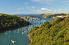
Hall Walk from Fowey to Polruan

Hall Walk from Fowey to Polruan
3.8 miles/6.1 km - Moderate-strenuous
A circular version of the famous Hall Walk from Bodinnick to Polruan, recorded as a walk with "sweete senting flowers" in Tudor times and during the Civil War where a gun shot aimed at Charles I is said to have instead killed a fisherman who stood on the same spot moments later.
-
4.2 miles/6.8 km - Moderate-strenuous
Polruan to Lantic Bay

Polruan to Lantic Bay
4.2 miles/6.8 km - Moderate-strenuous
A circular walk along the coast from Polruan to the white sandy beaches of Lantic Bay, returning via Lanteglos Church and along the creek with panoramic views of Fowey.
-
5 miles/8.1 km - Moderate-strenuous
Lerryn to St Veep

Lerryn to St Veep
5 miles/8.1 km - Moderate-strenuous
A circular walk from Lerryn, along wooded creeks and across fields, to the church of St Veep, which is the only one in England where the bells were cast in perfect tune.
-
6.7 miles/10.8 km - Moderate-strenuous
Polkerris, Gribbin Head and Readymoney Cove

Polkerris, Gribbin Head and Readymoney Cove
6.7 miles/10.8 km - Moderate-strenuous
A circular walk near Fowey, from the tiny harbour of Polkerris, past the daymark tower on Gribbin Head and along the coast where Daphne du Maurier lived and based many of her books on, to the sandy beach at Readymoney Cove, returning on the Saint's Way.


Download the iWalk Cornwall app and use the QR scanner within the app to find out more about any of the walks above.
From Fowey itself, there is the well-known Hall Walk route using the ferries to include both Fowey and Polruan. Alternatively, the circular route from Fowey to Polridmouth takes in many of the other places that Daphne Du Maurier spent her time. The longer route from Polkerris also includes the daymark tower on Gribbin Head which the National Trust allow to be climbed on certain days in the summer. On the opposite side of the estuary, there are circular routes to the sheltered sandy beaches of Lantic and Lantivet Bays.
