

Walks around Port Isaac
Enjoy the walks by being guided by the app


-
2.9 miles/4.7 km - Moderate
Port Quin to Lundy Bay

Port Quin to Lundy Bay
2.9 miles/4.7 km - Moderate
A circular walk from the fishing village of Port Quin to the golden sandy beaches of Epphaven Cove and Lundy Bay with spectacular coastal scenery, via the cliff-edge folly on Doyden Point built as a gambling den.
-
3.8 miles/6.1 km - Moderate
St Endellion to Port Isaac

St Endellion to Port Isaac
3.8 miles/6.1 km - Moderate
A figure-of-8 walk from St Endellion to Port Isaac, via the estate of the ancient family of Roscarrock, who survived torture on the rack during Tudor times for being Catholic sympathisers, returning to the parish church, dedicated to the daughter of a Celtic king, on the ancient route which itself influenced the fervent adoption of Methodism in Port Isaac.
-
5.5 miles/8.9 km - Moderate
St Kew, St Endellion and Tregellist

St Kew, St Endellion and Tregellist
5.5 miles/8.9 km - Moderate
A circular walk in the river valleys around St Kew - the first recorded village in Cornwall, passing the mediaeval church containing a gravestone from the Dark Ages carved in Latin and the Celtic script, Ogham, also known as the Tree Alphabet as each letter symbolised a different species of tree.
-
3.3 miles/5.3 km - Moderate-strenuous
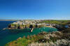
Port Isaac

Port Isaac
3.3 miles/5.3 km - Moderate-strenuous
A short circular walk in Doc Martin Country including the pretty fishing village of Port Isaac and the historic beach of Port Gaverne with birds-eye views over the harbour.
-
4.8 miles/7.7 km - Moderate-strenuous
Port Quin to Port Isaac

Port Quin to Port Isaac
4.8 miles/7.7 km - Moderate-strenuous
A circular walk along the rollercoaster path from Port Quin, descending into Port Isaac, with spectacular views of the harbour, via the old houses of Roscarrock Hill including Doc Martin's, one with roof timbers tied on by an anchor chain, and the Sunday School with a bell from a shipwreck.
-
6 miles/9.7 km - Moderate-strenuous
Port Gaverne to Barretts Zawn

Port Gaverne to Barretts Zawn
6 miles/9.7 km - Moderate-strenuous
A circular walk from Port Gaverne around Port Isaac Bay to Barretts Zawn, where a tunnel leads to the beach, through which donkeys used to haul slate.
-
9.4 miles/15.1 km - Moderate-strenuous
Port Isaac to Polzeath (via bus)

Port Isaac to Polzeath (via bus)
9.4 miles/15.1 km - Moderate-strenuous
A one-way coastal walk, made circular via an initial bus journey, from Port Isaac to Polzeath along the Rollercoaster Path to Port Quin, the golden beaches of Lundy Bay via the Iron Age hillfort on the twin headland of The Rumps.
-
4.7 miles/7.6 km - Strenuous
Barrett's Zawn and Dannonchapel

Barrett's Zawn and Dannonchapel
4.7 miles/7.6 km - Strenuous
A circular walk including some of the more remote parts of the coast path around Port Isaac Bay, passing the Donkey Hole at Barrett's Zawn and returning through the abandoned hamlet of Dannonchapel.
-
9.7 miles/15.6 km - Strenuous
Port Isaac to Tintagel

Port Isaac to Tintagel
9.7 miles/15.6 km - Strenuous
A one-way walk from Port Isaac to Tintagel along towering cliffs, past the long, sandy beaches of Tregardock and Trebarwith, the slate pinnacles of the coastal quarries and via the mediaeval cliff-top church to the castle of Arthurian legend.


Download the iWalk Cornwall app and use the QR scanner within the app to find out more about any of the walks above.
The coastline around Port Isaac is very rugged so the coastal walks are reasonably demanding but the scenery is superb. For a walk exploring Port Isaac itself, there's the short circular walk which includes Port Gaverne and Roscarrock Hill (of Doc Martin fame). There are also some longer walks visiting Port Isaac from St Endellion or Port Quin. Starting from Port Isaac, the walk to Barretts Zawn involves the epic climb of Ranie Head which is a perfect way to work up an appetite for a meal in Port Gaverne or Port Isaac afterwards. For a sandy beach, the walk from Port Quin to Lundy Bay is best done at low tide.
