

Circular walks around Falmouth
Enjoy the walks by being guided by the app


-
4.2 miles/6.8 km - Easy
Constantine to Scott's Quay
Constantine to Scott's Quay
4.2 miles/6.8 km - Easy
A circular walk at Constantine through woods and to the creek on the Helford river where a bustling quarrying and mining industry operated in Victorian times but have now been reclaimed by nature.
-
3.3 miles/5.4 km - Easy-moderate
Towan Beach to Place House

Towan Beach to Place House
3.3 miles/5.4 km - Easy-moderate
A walk on contrasting coastlines, from the rugged Roseland coast to the sheltered creeks of the Percuil River opposite St Mawes.
-
3.4 miles/5.4 km - Easy-moderate
St Anthony Head (short version)

St Anthony Head (short version)
3.4 miles/5.4 km - Easy-moderate
A walk on the Roseland coast and then into the Fal estuary to St Anthony Church via the fort St Anthony Head and the golden sandy beaches of Molunan.
-
4 miles/6.5 km - Easy-moderate
Mylor and Restronguet Creeks

Mylor and Restronguet Creeks
4 miles/6.5 km - Easy-moderate
A circular walk along the Mylor and Restronguet creeks via the Pandora Inn, said to be once owned and renamed by the captain of HMS Pandora sent to capture mutineers from The Bounty, and where a passing-boat was kept to connect the post road between Falmouth and Truro, summoned by a bell on the other side of the creek.
-
4.1 miles/6.5 km - Easy-moderate
Mylor to Flushing

Mylor to Flushing
4.1 miles/6.5 km - Easy-moderate
A circular walk from Mylor Harbour along the creeks of Carrick Roads to Flushing which was named after a town in Holland when Dutch engineers built the quays, and where ships' captains would keep a watchful eye over Falmouth Harbour from their tall houses.
-
5.3 miles/8.6 km - Easy-moderate
Falmouth and Pendennis Head

Falmouth and Pendennis Head
5.3 miles/8.6 km - Easy-moderate
A circular walk around the thriving town of Falmouth, which didn't exist until Elizabethan times when Sir Walter Raleigh suggested that the largest natural harbour in Europe would be a good place to build a port town.
-
5.8 miles/9.4 km - Easy-moderate
Rosemullion Head

Rosemullion Head
5.8 miles/9.4 km - Easy-moderate
A circular walk passing the National Trust's Glendurgan gardens and the equally spectacular submarine gardens of Rosemullion Head where fish dart amongst the brightly-coloured blooms.
-
5.9 miles/9.5 km - Easy-moderate
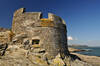
St Anthony Head

St Anthony Head
5.9 miles/9.5 km - Easy-moderate
A walk along the Roseland coast and creeks opposite St Mawes, passing the preserved fort and Fraggle Rock lighthouse on St Anthony Head and the golden sandy beaches of Molunan.
-
6 miles/9.6 km - Easy-moderate
Stithians to Kennall Vale

Stithians to Kennall Vale
6 miles/9.6 km - Easy-moderate
A circular walk in the valley of the River Kennall, where during Victorian times the cascading river was used to power gunpowder mills, five of which exploded in a chain reaction so violent that the roof of one was found a mile away.
-
6.1 miles/9.8 km - Easy-moderate
Feock to Devoran

Feock to Devoran
6.1 miles/9.8 km - Easy-moderate
A circular walk to the Victorian-engineered town of Devoran which was once the largest mining port in Cornwall, and along Restronguet Creek on the route of the railway that lead from the ore bins and smelting houses to the mines of Redruth
-
6.5 miles/10.5 km - Easy-moderate
Budock Water and the Lakes

Budock Water and the Lakes
6.5 miles/10.5 km - Easy-moderate
A walk from what was once the parish church for Falmouth to the lakes in a river valley which the Celtic people described as secluded and where Argal Mill lies somewhere beneath the water in a Cornish version of Atlantis.
-
6.7 miles/10.8 km - Easy-moderate
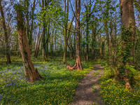
Penryn Creeks and Enys

Penryn Creeks and Enys
6.7 miles/10.8 km - Easy-moderate
A circular walk along the creeks of Carrick Roads and through the woodland of the Enys Estate, famous for its bluebells in spring
-
4 miles/6.4 km - Moderate
Towan Beach to Portscatho

Towan Beach to Portscatho
4 miles/6.4 km - Moderate
A circular walk on the Roseland coast where, during the Napoleonic Wars, smugglers would row out to the middle of The Channel in pilot gigs to trade with the enemy.
-
6.1 miles/9.8 km - Moderate
St Just-in-Roseland to St Mawes

St Just-in-Roseland to St Mawes
6.1 miles/9.8 km - Moderate
A circular walk on the Roseland peninsula to St Mawes from the subtropical gardens of St Just church, along Carrick Roads where Europe's only fishery entirely under sail catch oysters using the traditional methods that have sustained their stocks.
-
6.3 miles/10.1 km - Moderate
Helford Passage

Helford Passage
6.3 miles/10.1 km - Moderate
A circular walk on the Helford River, where the mild climate and south-facing slopes allow subtropical plants collected by Victorian expeditions to flourish in the gardens of Glendurgan and Trebah.
-
7.2 miles/11.5 km - Moderate
Maenporth to Budock Water

Maenporth to Budock Water
7.2 miles/11.5 km - Moderate
A circular walk between the beaches in Falmouth Bay and where one of the most dangerous marine rescues of modern times took place, requiring the rescue helicopter to fly backwards.


Download the iWalk Cornwall app and use the QR scanner within the app to find out more about any of the walks above.
