

Circular walks around Helston
Enjoy the walks by being guided by the app


-
2.9 miles/4.7 km - Easy
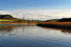
Helston

Helston
2.9 miles/4.7 km - Easy
A circular walk at Helston along the wooded valley of the River Cober and through the town via the church.
-
4.2 miles/6.8 km - Easy
Constantine to Scott's Quay
Constantine to Scott's Quay
4.2 miles/6.8 km - Easy
A circular walk at Constantine through woods and to the creek on the Helford river where a bustling quarrying and mining industry operated in Victorian times but have now been reclaimed by nature.
-
3.3 miles/5.3 km - Easy-moderate
Penrose to the Loe Bar

Penrose to the Loe Bar
3.3 miles/5.3 km - Easy-moderate
A circular walk alongside the Loe Pool to the Loe Bar and back via the farm on the hill spur, which in Cornish gave the name to the Penrose Estate.
-
3.9 miles/6.2 km - Easy-moderate
Crowan to Clowance Estate

Crowan to Clowance Estate
3.9 miles/6.2 km - Easy-moderate
A circular walk in the parish of Crowan from the church to the Clowance Estate - the mansion of the St Aubyn Baronets until the fifth Baronet failed to produce a legitimate heir due to his 15 children all being born to women not married to him.
-
about 5.1 miles/8.3 km - Easy-moderate
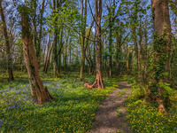
Helston and Cober Valley

Helston and Cober Valley
about 5.1 miles/8.3 km - Easy-moderate
A circular walk from Helston along the Cober Valley to the granite quarries at Coverack Bridges, where the viaduct of the Helston Railway can still be seen spanning the valley.
-
6 miles/9.6 km - Easy-moderate
Penrose and Porthleven

Penrose and Porthleven
6 miles/9.6 km - Easy-moderate
A circular walk through the woodland alongside the Loe to the most southerly port on the British mainland, famous for its huge storm waves.
-
6 miles/9.7 km - Easy-moderate
Praa Sands to Prussia Cove

Praa Sands to Prussia Cove
6 miles/9.7 km - Easy-moderate
A circular walk on Cornwall's Channel coast where horses carried ore, Victorian fishermen built huts and smugglers sailed to France, but before all this Neolithic people settled and worked flints carried down the English Channel from chalk areas during the Ice Age
-
6.2 miles/10 km - Easy-moderate
The Loe

The Loe
6.2 miles/10 km - Easy-moderate
A circular walk around the Loe Pool, the largest natural freshwater lake in Cornwall, and along the Loe Bar, one of Cornwall's most treacherous beaches on which 100 of those onboard the HMS Anson drowned metres from the shore, motivating the invention of the rocket lifesaving apparatus that saved thousands of lives.
-
4.4 miles/7 km - Moderate
Praa Sands to Trewavas Mine

Praa Sands to Trewavas Mine
4.4 miles/7 km - Moderate
A circular walk from Praa sands across Rinsey Head to the engine house of the ironically-named Wheal Prosper, and Trewavas mine where an engine house now forms part of the path
-
4.8 miles/7.8 km - Moderate
Godolphin to Tregonning

Godolphin to Tregonning
4.8 miles/7.8 km - Moderate
A circular walk from the mansion with possibly the oldest formal gardens in the country to two hills that altered the course of history, creating the wealthiest estate in Cornwall and giving rise to the Cornish China Clay industry.
-
5.3 miles/8.5 km - Moderate
Gunwalloe Coves

Gunwalloe Coves
5.3 miles/8.5 km - Moderate
A circular walk from the Loe Bar to Dollar Cove passing the wrecks of treasure ships whose cargo still washes ashore, returning via the Halzephron Inn which still has a trapdoor leading to an underground network of tunnels used by smugglers.
-
6.8 miles/10.9 km - Moderate-strenuous
Porthleven to Rinsey Head

Porthleven to Rinsey Head
6.8 miles/10.9 km - Moderate-strenuous
A circular walk from Porthleven to the cliff-edge engine houses of Rinsey Head and Trewavas where the under-sea mine, set out with tables and food for the annual Tribute dinner, is said to have been breached by the sea just minutes before all the miners were due underground.


Download the iWalk Cornwall app and use the QR scanner within the app to find out more about any of the walks above.
