

Circular walks around Truro
Enjoy the walks by being guided by the app


-
4.4 miles/7.1 km - Easy
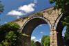
Truro and the old Newham railway

Truro and the old Newham railway
4.4 miles/7.1 km - Easy
A circular walk at Truro along the river, trackbed of the Newham railway and through the historic city centre.
-
3.8 miles/6.1 km - Easy-moderate
St Clement and Malpas

St Clement and Malpas
3.8 miles/6.1 km - Easy-moderate
A circular walk at the confluence of the Truro and Tresillian rivers, once defended by Moresk castle and later where timber for the mines was unloaded and floated as rafts into Truro
-
4.7 miles/7.6 km - Easy-moderate
Trelissick

Trelissick
4.7 miles/7.6 km - Easy-moderate
A figure-of-8 walk along the creeks of the River Fal through the 300 acre estate surrounding Trelissick House.
-
6.1 miles/9.8 km - Easy-moderate
Feock to Devoran

Feock to Devoran
6.1 miles/9.8 km - Easy-moderate
A circular walk to the Victorian-engineered town of Devoran which was once the largest mining port in Cornwall, and along Restronguet Creek on the route of the railway that lead from the ore bins and smelting houses to the mines of Redruth
-
6.4 miles/10.2 km - Easy-moderate
Truro to Roseworthy

Truro to Roseworthy
6.4 miles/10.2 km - Easy-moderate
A circular walk in the Kenwyn valley following the Kenwyn upriver from Truro's Victoria Gardens where the elaborate Victorian system of weir gates, a hydraulic ram and leats both maintained the fish pond in the gardens and provided drinking water for horses in the city centre.
-
4.2 miles/6.7 km - Moderate
Coombe and Old Kea

Coombe and Old Kea
4.2 miles/6.7 km - Moderate
A circular walk on the creeks of the Fal river network settled by Celtic monks where the ruin of a huge mediaeval church still towers above the trees
-
4.8 miles/7.7 km - Moderate
Grampound to Trenowth

Grampound to Trenowth
4.8 miles/7.7 km - Moderate
A circular walk in the Fal valley from Grampound which began as river port in Roman times which evolved into the gateway into West Cornwall in mediaeval times and went on to become the centre of Cornwall's tanning industry.
-
4.9 miles/7.8 km - Moderate
Ladock Woods and Holy Well

Ladock Woods and Holy Well
4.9 miles/7.8 km - Moderate
A circular walk from the woodland of The Duchy to the Holy Well of St Ladock in the river valley where in 1802 a gold nugget was found that contained enough gold to make an elegant necklace which is now in Truro museum.
-
5.3 miles/8.5 km - Moderate
Callestick and Ventongimps

Callestick and Ventongimps
5.3 miles/8.5 km - Moderate
A circular countryside walk past the nature reserve at Ventongimps and the engine house of West Chyverton mine, with refreshment opportunities at both Callestick Farm, where you can see the ice cream being made, and Healey's Cyder Farm who offer tours and tasting.


Download the iWalk Cornwall app and use the QR scanner within the app to find out more about any of the walks above.
