

Circular walks around The Roseland
Enjoy the walks by being guided by the app


-
3.3 miles/5.4 km - Easy-moderate
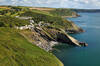
Towan Beach to Place House

Towan Beach to Place House
3.3 miles/5.4 km - Easy-moderate
A walk on contrasting coastlines, from the rugged Roseland coast to the sheltered creeks of the Percuil River opposite St Mawes.
-
3.4 miles/5.4 km - Easy-moderate
St Anthony Head (short version)

St Anthony Head (short version)
3.4 miles/5.4 km - Easy-moderate
A walk on the Roseland coast and then into the Fal estuary to St Anthony Church via the fort St Anthony Head and the golden sandy beaches of Molunan.
-
3.7 miles/6 km - Easy-moderate
St Just-in-Roseland to Messack Point

St Just-in-Roseland to Messack Point
3.7 miles/6 km - Easy-moderate
A circular walk on the Roseland along both sides of St Just creek to Messack Point, where there are spectacular views over one of the largest natural harbours in the world.
-
5.9 miles/9.5 km - Easy-moderate
St Anthony Head

St Anthony Head
5.9 miles/9.5 km - Easy-moderate
A walk along the Roseland coast and creeks opposite St Mawes, passing the preserved fort and Fraggle Rock lighthouse on St Anthony Head and the golden sandy beaches of Molunan.
-
3.4 miles/5.4 km - Moderate
Mevagissey to Portmellon

Mevagissey to Portmellon
3.4 miles/5.4 km - Moderate
A circular walk from the busy fishing port of Mevagissey into the Portmellon Valley and through the West Bodrugan Woods nature reserve to the beachside village of Portmellon where boats have been built for hundreds of years, and still are.
-
4 miles/6.4 km - Moderate
Towan Beach to Portscatho

Towan Beach to Portscatho
4 miles/6.4 km - Moderate
A circular walk on the Roseland coast where, during the Napoleonic Wars, smugglers would row out to the middle of The Channel in pilot gigs to trade with the enemy.
-
4.4 miles/7 km - Moderate
Portscatho to Pendower Beach

Portscatho to Pendower Beach
4.4 miles/7 km - Moderate
A circular walk along two miles of beaches around Gerrans Bay which were once used by Portscatho smugglers to land contraband and strewn with the wreckage of sailing ships that overshot Falmouth Harbour and ran aground on The Whelps reef.
-
4.9 miles/7.9 km - Moderate
Gorran Haven to Dodman Point

Gorran Haven to Dodman Point
4.9 miles/7.9 km - Moderate
A circular walk in the bays of Mevagissey and Veryan from the fishing village of Gorran Haven to the remote, sandy Hemmick Beach via The Deadman's Point of old nautical maps, still marked with a huge cross to warn sailors of the perilous lee shores, and Vault Beach where the wreckage washed ashore.
-
5.3 miles/8.5 km - Moderate
Pendower Beach to Veryan

Pendower Beach to Veryan
5.3 miles/8.5 km - Moderate
A circular walk from Pendower Beach to Veryan via Nare Head where, in Victorian times, an unhappily married fisherman lived alone in a cliff-edge cottage, lowering his boat on a rope over the cliff and returning once a week to Veryan to bring his wife fish.
-
6.1 miles/9.8 km - Moderate
St Just-in-Roseland to St Mawes

St Just-in-Roseland to St Mawes
6.1 miles/9.8 km - Moderate
A circular walk on the Roseland peninsula to St Mawes from the subtropical gardens of St Just church, along Carrick Roads where Europe's only fishery entirely under sail catch oysters using the traditional methods that have sustained their stocks.
-
3.8 miles/6.1 km - Moderate-strenuous
Caerhays Castle to Hemmick Beach

Caerhays Castle to Hemmick Beach
3.8 miles/6.1 km - Moderate-strenuous
A circular walk around Veryan Bay between two sandy beaches from Caerhays Castle where the gardens contain nationally-important collections from the expeditions of Victorian plant hunters
-
3.9 miles/6.3 km - Moderate-strenuous
Portholland to Portloe

Portholland to Portloe
3.9 miles/6.3 km - Moderate-strenuous
A circular walk with lovely views of Veryan Bay to the pretty fishing village of Portloe from West Portholland, where one of the last of Cornwall's mediaeval coastal farmsteads has survived.
-
5.2 miles/8.3 km - Moderate-strenuous
Nare Head to Portloe

Nare Head to Portloe
5.2 miles/8.3 km - Moderate-strenuous
A circular walk around Nare Head, past the restored Cold War nuclear bunker, to the pretty fishing village of Portloe, with views along the length of The Roseland coast and over The Whelps reef - a graveyard for sailing ships that misjudged the entrance to Falmouth.


Download the iWalk Cornwall app and use the QR scanner within the app to find out more about any of the walks above.
There are a number of circular walks on both side of The Roseland peninsula. In Veryan Bay there are circular walks around Dodman Point, and to Portloe from either side which could be combined into a longer walk. Circular walks in Gerrans Bay include one from Towan Beach to Portscatho and Portscatho to Pendower Beach. Within Carrick Roads there are some popular circular walks around St Anthony Head and to St Mawes from St Just.
