

Walks in Cornwall least likely to have deep mud
Enjoy the walks by being guided by the app


Some mud should be expected on all routes after wet weather and during winter months when the ground doesn't get enough sunlight to dry out. The routes listed here are where deep mud (beyond a walking boot deep) is less likely.
Please note that this is NOT guaranteed as livestock are constantly moved and a large vehicle such as a tractor can quickly churn up a previously grassy track. If you walk one of these routes and do find deep mud, let us know and we'll remove it from the list for the benefit of other walkers.
An alternative strategy for winter walks is to welly-up ready for mud but select shorter walk routes which are more comfortable to complete in wellies than the longer distance routes. We also find mucker boots (which have a thicker, more cushioned sole) better for longer distances and stony ground than classic wellies.
-
2.2 miles/3.6 km - Easy
Eden Project

Eden Project
2.2 miles/3.6 km - Easy
A walk though a granite landscape mined first for tin, then china clay and now for geothermal power to generate electricity and heat the space-age greenhouses of the Eden Project.
-
2.5 miles/4 km - Easy
Botallack Head

Botallack Head
2.5 miles/4 km - Easy
A circular walk around Cornwall's most iconic mining remains, used for the filming of the BBC's Poldark series
-
2.7 miles/4.3 km - Easy
Hayle and The Towans

Hayle and The Towans
2.7 miles/4.3 km - Easy
A circular walk on the Towans at Hayle, where Cornwall's beam engines were cast using sand from a prehistoric lagoon when West Penwith was an island. The walk is all on sandy ground or tarmac.
-
3.5 miles/5.6 km - Easy
Bude to Northcott Mouth

Bude to Northcott Mouth
3.5 miles/5.6 km - Easy
A circular walk past the Sea Pool to Crooklets beach and along Maer cliff to the beach at Northcott Mouth, where the shipwreck of the SS Belem is exposed at low tide. The route at the Bude end is on tarmac. The coast path and bridleway to Northcott Mouth aren't usually excessively muddy. At low tide, it's also possible to walk along the sand instead of the coast path to Northcott Mouth.
-
3.7 miles/6 km - Easy
Polzeath to St Enodoc Church

Polzeath to St Enodoc Church
3.7 miles/6 km - Easy
A circular walk along the coast from Polzeath past a number of small coves to the vast sandy beach at Daymer Bay, returning through the dunes past St Enodoc Church which was once so deeply buried in the sand that entrance for services was through the roof.
-
3.9 miles/6.3 km - Easy
Bude Canal and Coast

Bude Canal and Coast
3.9 miles/6.3 km - Easy
A figure-of-8 walk at Bude where the demand for lime-rich sand could not even be met by 4000 horses a day and so a 35-mile canal was built to transport it to the Tamar Valley. All of the route is on surfaced paths.
-
6 miles/9.7 km - Easy
Marazion to Penzance
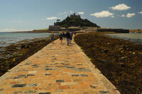
Marazion to Penzance
6 miles/9.7 km - Easy
A circular walk around Mount's Bay where the remains of the prehistoric forest that surrounded St Michael's Mount can still occasionally be seen on very low tides after storms
-
2.2 miles/3.6 km - Easy-moderate
West Pentire and Polly Joke

West Pentire and Polly Joke
2.2 miles/3.6 km - Easy-moderate
A circular walk through the poppy fields of West Pentire to Polly Joke beach, returning over the headland to the pub that was a cowshed until the mid-20th Century.
-
2.4 miles/3.8 km - Easy-moderate
Gwithian and Upton Towans

Gwithian and Upton Towans
2.4 miles/3.8 km - Easy-moderate
A circular walk around the nature reserve in the sand dunes that was once the National Explosives Works where young girls manufactured dynamite from nitroglycerine, two tonnes of which detonated causing a shock wave that broke windows in St Ives and Penzance and could be heard on Dartmoor. The walk is all on sandy ground.
-
2.5 miles/4 km - Easy-moderate
Bodmin town and beacon

Bodmin town and beacon
2.5 miles/4 km - Easy-moderate
A circular walk to the Beacon Local Nature Reserve, Jail and through Bodmin's historic centre. Most of the route is on tarmac. There's a fairly short off-tarmac section at The Beacon along an unsurfaced track and field edge to reach the Gilbert monument.
-
3.2 miles/5.1 km - Easy-moderate
Lanhydrock Gardens

Lanhydrock Gardens
3.2 miles/5.1 km - Easy-moderate
A fairly short and easy circular walk through Lanhydrock gardens with plenty of picnic spots along the River Fowey that you can combine with a visit to the house.
-
3.4 miles/5.4 km - Easy-moderate
Wheal Maid and Poldice Valley

Wheal Maid and Poldice Valley
3.4 miles/5.4 km - Easy-moderate
A circular walk in the area described in Victorian times as the richest square mile anywhere on Earth
-
3.6 miles/5.8 km - Easy-moderate
Lost Church and Perranporth dunes

Lost Church and Perranporth dunes
3.6 miles/5.8 km - Easy-moderate
A circular walk on the highest dune system in Britain to the chapel dating from Celtic times which was lost in the dunes for nearly 1000 years. The walk is on sandy ground. The area around the Oratory does flood but can be bypassed.
-
3.9 miles/6.2 km - Easy-moderate
Holywell to Polly Joke

Holywell to Polly Joke
3.9 miles/6.2 km - Easy-moderate
A circular walk from Holywell Bay on the dunes and Kelsey Head to the sandy beach of Polly Joke. The walk is mostly on sandy ground.
-
3.9 miles/6.3 km - Easy-moderate
Land's End

Land's End
3.9 miles/6.3 km - Easy-moderate
A circular walk on the rugged cliffs at the most westerly point of the British mainland with spectacular views and spectacular wildflowers.
-
3.9 miles/6.3 km - Easy-moderate
Penzance to Newlyn

Penzance to Newlyn
3.9 miles/6.3 km - Easy-moderate
A circular walk at Mount's Bay from the largest port town in the bay to the harbour of Cornwall's largest fishing fleet.
-
4 miles/6.4 km - Easy-moderate
Watergate Bay to Newquay (via bus)

Watergate Bay to Newquay (via bus)
4 miles/6.4 km - Easy-moderate
A one-way coastal walk, made circular via an initial bus journey, from Watergate Bay along the coast path to Newquay, passing the sea caves at Whipsiderry beach, the Iron Age hillfort on Trevelgue head and the beaches of Porth, Lusty Glaze and Tolcarne.
-
4.3 miles/7 km - Easy-moderate
Tehidy Woods to Deadman's Cove

Tehidy Woods to Deadman's Cove
4.3 miles/7 km - Easy-moderate
A circular walk through the wildlife reserve and bluebell woodland of Tehidy Country Park to Deadman's Cove and the North Cliffs, where many sailing ships were wrecked before the Godrevy Lighthouse was built.
-
4.9 miles/7.9 km - Easy-moderate
Holywell to Crantock

Holywell to Crantock
4.9 miles/7.9 km - Easy-moderate
A circular walk from Holywell Bay past the remarkable sacred spring and along the coast to the sandy beaches of Porth Joke and Crantock, returning via the poppy fields of West Pentire and the Cubert Common nature conservation area. The walk is mostly on sandy ground.
-
5 miles/8 km - Easy-moderate
St Austell, Clay Trails and Menacuddle Well

St Austell, Clay Trails and Menacuddle Well
5 miles/8 km - Easy-moderate
A circular walk in china clay country, including a trail laid on the trackbed of a mineral railway from St Austell to the Cornish Alps and one of Cornwall's most picturesque holy wells.
-
5.3 miles/8.6 km - Easy-moderate
Falmouth and Pendennis Head

Falmouth and Pendennis Head
5.3 miles/8.6 km - Easy-moderate
A circular walk around the thriving town of Falmouth, which didn't exist until Elizabethan times when Sir Walter Raleigh suggested that the largest natural harbour in Europe would be a good place to build a port town.
-
5.8 miles/9.4 km - Easy-moderate
Rock to Polzeath

Rock to Polzeath
5.8 miles/9.4 km - Easy-moderate
A circular walk across the dunes and headland between Rock and Polzeath, returning via St Enodoc Church, where Sir John Betjeman is buried.
-
2.5 miles/4 km - Moderate
Danescombe Valley

Danescombe Valley
2.5 miles/4 km - Moderate
A circular walk from Cotehele Quay into the broadleaf woodland of the Danescombe Valley where bluebells and orchids flower in spring and fungi erupt through the carpet of autumn leaves.
-
3.3 miles/5.3 km - Moderate
Boscastle Headlands

Boscastle Headlands
3.3 miles/5.3 km - Moderate
A circular walk from Boscastle to Pentargon waterfall and Willapark coastguard lookout with magnificent views of the village and harbour from the headlands where the village women once gathered dressed in red to fool a French ship into fleeing from British army redcoats.
-
3.6 miles/5.8 km - Moderate
Portwrinkle to Sheviock

Portwrinkle to Sheviock
3.6 miles/5.8 km - Moderate
A circular walk from the beach and tiny harbour of Portwrinkle to the small village of Sheviock, thought to be Cornish for "abounding in strawberries", with a church abounding in mediaeval tombs. Although the path along the river after Sheviock can get a bit muddy, this can easily be avoided by walking amongst the greenery adjacent.
-
3.9 miles/6.2 km - Moderate
Cotehele to Metherell

Cotehele to Metherell
3.9 miles/6.2 km - Moderate
A circular walk via the quays, woods, engine house and mills of the Cotehele Estate where by Georgian times the house had become a tourist attraction because it was so antiquated, and has changed little since.
-
4.4 miles/7 km - Moderate
Portscatho to Pendower Beach

Portscatho to Pendower Beach
4.4 miles/7 km - Moderate
A circular walk along two miles of beaches around Gerrans Bay which were once used by Portscatho smugglers to land contraband and strewn with the wreckage of sailing ships that overshot Falmouth Harbour and ran aground on The Whelps reef.
-
5.2 miles/8.3 km - Moderate
Sennen Cove to Nanquidno

Sennen Cove to Nanquidno
5.2 miles/8.3 km - Moderate
A circular walk alongside the pristine beaches of Whitesand Bay, where shoals of mullet are still caught off the beach using the traditional seine nets in the way they have for hundreds of years.
-
5.3 miles/8.5 km - Moderate
Lanhydrock to Restormel

Lanhydrock to Restormel
5.3 miles/8.5 km - Moderate
A circular walk from the mediaeval bridge at Respryn along the River Fowey through the bluebell woodland of the Lanhydrock Estate to the circular Norman castle at Restormel which had a pressurised piped water system 700 years ahead of its time. Most of the route is on hard surfaces. Tracks through the woods near the Duchy Nursery are the main areas likely to get muddy in winter.
-
5.8 miles/9.3 km - Moderate
Newquay

Newquay
5.8 miles/9.3 km - Moderate
A circular walk around the UK's surf capital which was transformed from a tiny fishing village with a few thatched cottages when, in order to export ore from the harbour, a horse-drawn tramway was built across Cornwall which later became part of the Great Western Railway.
-
6 miles/9.6 km - Moderate-strenuous
Seaton to Millendreath

Seaton to Millendreath
6 miles/9.6 km - Moderate-strenuous
A circular walk in an area of Cornwall so off the beaten track that No Man's Land is a real place name and a breeding colony of monkeys live in the woodland, in a sanctuary set up by the father of the classical guitarist, John Williams.


Download the iWalk Cornwall app and use the QR scanner within the app to find out more about any of the walks above.
