

Carlyon Bay
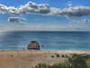
Before the 19th Century there were no beaches at high tide at Carlyon Bay. The beaches today were formed from the mineral waste washed down the (appropriately-named) Sandy River and consequently the "sand" is quite gritty. By the time the first edition OS map was recorded in the 1880s, the low water mark was roughly where it is now but the amount of beach at high tide has increased further since then. Climate change may reverse that.
Carlyon Bay consists of three (now joined) beaches: Crinnis - where the path leads down from the road, Shorthorn - in the middle, and Polgaver - at the far end, which was Cornwall's first nudist beach but is a little too public for that now. The relatively chunky quartz particles within the sand, as well as being sharp to walk on in bare feet (and presumably uncomfortable for nudists), don't drift around like the more ancient fine sand found on most Cornish beaches so the sea can pile it up more easily, sometimes resulting in some steep drops in the beach gradient concealed beneath the water which can surprise paddlers.
Circular walks visiting Carlyon Bay
-
5.3 miles/8.5 km - Moderate
Charlestown and Carlyon Bay
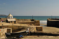
Charlestown and Carlyon Bay
5.3 miles/8.5 km - Moderate
A circular walk along the Cornish Riviera coastline frequented by royalty in the Roaring 20s, from the ingeniously-designed copper port now popular with film directors for its tall ships
-
6.2 miles/9.9 km - Moderate
Par and St Blazey
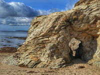
Par and St Blazey
6.2 miles/9.9 km - Moderate
A circular walk at Par where the land itself was created by the mining industry and is being re-sculpted by nature into sandy beaches, streams and woodland.


Download the iWalk Cornwall app and use the QR scanner within the app to find out more about any of the walks above.