

Circular walks around Mounts Bay
Enjoy the walks by being guided by the app


-
6 miles/9.7 km - Easy
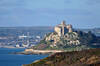
Marazion to Penzance
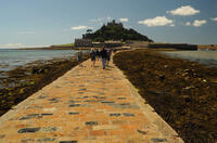
Marazion to Penzance
6 miles/9.7 km - Easy
A circular walk around Mount's Bay where the remains of the prehistoric forest that surrounded St Michael's Mount can still occasionally be seen on very low tides after storms
-
3.3 miles/5.3 km - Easy-moderate
Penrose to the Loe Bar

Penrose to the Loe Bar
3.3 miles/5.3 km - Easy-moderate
A circular walk alongside the Loe Pool to the Loe Bar and back via the farm on the hill spur, which in Cornish gave the name to the Penrose Estate.
-
3.9 miles/6.3 km - Easy-moderate
Penzance to Newlyn

Penzance to Newlyn
3.9 miles/6.3 km - Easy-moderate
A circular walk at Mount's Bay from the largest port town in the bay to the harbour of Cornwall's largest fishing fleet.
-
4.9 miles/7.9 km - Easy-moderate
Marazion to Perranuthnoe

Marazion to Perranuthnoe
4.9 miles/7.9 km - Easy-moderate
A mostly circular walk to Perranuthnoe beach from one of Britain's most ancient towns - Marazion - burnt down twice by the French and once more in a Cornish rebellion
-
6 miles/9.6 km - Easy-moderate
Penrose and Porthleven

Penrose and Porthleven
6 miles/9.6 km - Easy-moderate
A circular walk through the woodland alongside the Loe to the most southerly port on the British mainland, famous for its huge storm waves.
-
6 miles/9.7 km - Easy-moderate
Praa Sands to Prussia Cove

Praa Sands to Prussia Cove
6 miles/9.7 km - Easy-moderate
A circular walk on Cornwall's Channel coast where horses carried ore, Victorian fishermen built huts and smugglers sailed to France, but before all this Neolithic people settled and worked flints carried down the English Channel from chalk areas during the Ice Age
-
6.2 miles/10 km - Easy-moderate
The Loe

The Loe
6.2 miles/10 km - Easy-moderate
A circular walk around the Loe Pool, the largest natural freshwater lake in Cornwall, and along the Loe Bar, one of Cornwall's most treacherous beaches on which 100 of those onboard the HMS Anson drowned metres from the shore, motivating the invention of the rocket lifesaving apparatus that saved thousands of lives.
-
3.9 miles/5.8 km - Moderate
Newlyn to Mousehole

Newlyn to Mousehole
3.9 miles/5.8 km - Moderate
A circular walk at the heart of Cornwall's fishing industry to the village where Stargazy Pie was invented and a candle-lit parade is held each year to celebrate the catch of Tom Bawcock.
-
3.9 miles/6.3 km - Moderate
Perranuthnoe to Prussia Cove
")
Perranuthnoe to Prussia Cove
3.9 miles/6.3 km - Moderate
A circular walk along Mount's Bay from the large sandy beach at Perranuthnoe to the smugglers' coves at Prussia Cove, returning across the fields with views over St Michael's Mount.
-
4.4 miles/7 km - Moderate
Praa Sands to Trewavas Mine

Praa Sands to Trewavas Mine
4.4 miles/7 km - Moderate
A circular walk from Praa sands across Rinsey Head to the engine house of the ironically-named Wheal Prosper, and Trewavas mine where an engine house now forms part of the path
-
4.5 miles/7.2 km - Moderate
Mullion three coves

Mullion three coves
4.5 miles/7.2 km - Moderate
A walk to the Victorian harbour of Mullion Cove via two sandy coves either side of where Marconi made history by achieving what was thought impossible by many of the scientific community at the time - the transmission of a radio signal all the way across the Atlantic.
-
4.8 miles/7.8 km - Moderate
Godolphin to Tregonning

Godolphin to Tregonning
4.8 miles/7.8 km - Moderate
A circular walk from the mansion with possibly the oldest formal gardens in the country to two hills that altered the course of history, creating the wealthiest estate in Cornwall and giving rise to the Cornish China Clay industry.
-
5.3 miles/8.5 km - Moderate
Gunwalloe Coves

Gunwalloe Coves
5.3 miles/8.5 km - Moderate
A circular walk from the Loe Bar to Dollar Cove passing the wrecks of treasure ships whose cargo still washes ashore, returning via the Halzephron Inn which still has a trapdoor leading to an underground network of tunnels used by smugglers.
-
6.2 miles/10 km - Moderate
Mullion to Predannack

Mullion to Predannack
6.2 miles/10 km - Moderate
A circular walk passing the sandy beach at Polurrian Cove, the storm-beaten Victorian harbour at Mullion Cove, and along the cliffs of the National Nature Reserve overlooking Mullion Island, with vibrant wildflowers in spring and summer.
-
7.6 miles/12.3 km - Moderate
Poldhu Cove to Cury

Poldhu Cove to Cury
7.6 miles/12.3 km - Moderate
A circular walk via some of the mediaeval farmsteads on the west of The Lizard to the ancient churchyard of Cury from the coves of Mullion and Gunwalloe where the wrecks of treasure ships still lie.
-
4.8 miles/7.8 km - Moderate-strenuous
Mousehole to Lamorna Cove

Mousehole to Lamorna Cove
4.8 miles/7.8 km - Moderate-strenuous
A circular walk following the coast from the historic fishing village of Mousehole through the Kemyel Crease nature reserve and around the towering cliffs of Lamorna Cove with views over Mount's Bay, returning along the route was that taken by the Victorian postman on his round from Penzance.
-
6.8 miles/10.9 km - Moderate-strenuous
Porthleven to Rinsey Head

Porthleven to Rinsey Head
6.8 miles/10.9 km - Moderate-strenuous
A circular walk from Porthleven to the cliff-edge engine houses of Rinsey Head and Trewavas where the under-sea mine, set out with tables and food for the annual Tribute dinner, is said to have been breached by the sea just minutes before all the miners were due underground.


")


Download the iWalk Cornwall app and use the QR scanner within the app to find out more about any of the walks above.
