

Circular walks around Altarnun
Enjoy the walks by being guided by the app


-
5.1 miles/8.2 km - Easy-moderate
Polyphant

Polyphant
5.1 miles/8.2 km - Easy-moderate
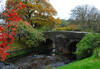
A circular countryside walk to the mills in the Inny Valley from Polyphant, Cornish for "toad pool", to Gimblett's Mill where the bridge was rebuilt after a wall of water swept down the valley in 1847 destroying nearly everything in its path.
-
5.5 miles/8.8 km - Easy-moderate
Altarnun and West Moor

Altarnun and West Moor
5.5 miles/8.8 km - Easy-moderate
A walk from Altarnun across the downs and out onto the open moor where the relics of mediaeval tin workings and prehistoric roundhouses can still be seen
-
4 miles/6.5 km - Moderate
Bowithick to Buttern Hill

Bowithick to Buttern Hill
4 miles/6.5 km - Moderate
A circular walk over the northern tip of Bodmin Moor to the prehistoric burial chamber at the top of Buttern Hill and source of the River Fowey, returning via farm tracks and country lanes to the tributary streams of the River Inny.
-
5.6 miles/9.0 km - Moderate
St Clether to the Rising Sun

St Clether to the Rising Sun
5.6 miles/9.0 km - Moderate
A figure-of-8 walk from St Clether past the ancient chapel and holy well, with views over the Inny Valley, to the Rising Sun pub near Altarnun, serving beer made from the moorland springwater by a local micro-brewery.
-
6.2 miles/10 km - Moderate
East Moor and Lynher Valleys

East Moor and Lynher Valleys
6.2 miles/10 km - Moderate
A circular walk in one of the less well-known areas of Bodmin Moor to the summit of Fox Tor and through the prehistoric remains which date from the Bronze Age and Neolithic times.
-
6.6 miles/10.6 km - Moderate
Inny Valleys from Altarnun

Inny Valleys from Altarnun
6.6 miles/10.6 km - Moderate
A circular walk around the valleys of the River Inny and Penpont Water to the mediaeval church at Laneast and the old bridge at Gimlett's Mill from the 15th century "Cathedral of the Moors" in Altarnun, set beside a 6th Century Celtic cross where churches and chapels had been throughout the Dark Ages.
-
3.7 miles/5.9 km - Moderate-strenuous
North Hill to Hawks Tor

North Hill to Hawks Tor
3.7 miles/5.9 km - Moderate-strenuous
A circular walk along prehistoric trade routes in the Lynher valley from the village of North Hill where the granite was quarried to build Westminster Bridge.


Download the iWalk Cornwall app and use the QR scanner within the app to find out more about any of the walks above.
