

Walks in Cornwall with prehistoric remains
Enjoy the walks by being guided by the app


The walks include Iron Age fortified settlements, hillforts and cliff castles, and stone circles, menhirs, barrows and the remains of settlements dating from Bronze Age and Neolithic periods.
-
2.6 miles/4.2 km - Easy-moderate
Warbstow Cross and Bury

Warbstow Cross and Bury
2.6 miles/4.2 km - Easy-moderate
A fairly short and easy circular walk around Warbstow, crossing ramparts of the massive Iron Age hillfort, through fields and along country lanes lined with wildflowers, returning via the mediaeval church which is dedicated to the daughter of a Saxon King who was tutored by the Celtic Saint Morwenna.
-
3.9 miles/6.2 km - Easy-moderate
Stannon Moor prehistoric relics

Stannon Moor prehistoric relics
3.9 miles/6.2 km - Easy-moderate
A circular walk around Stannon Moor near St Breward with panoramic views of Bodmin Moor, passing stone circles, burial chambers and other prehistoric monuments to a massive granite boulder balanced on Louden Hill which gently rocks if you sit on it.
-
4 miles/6.4 km - Easy-moderate
Watergate Bay to Newquay (via bus)

Watergate Bay to Newquay (via bus)
4 miles/6.4 km - Easy-moderate
A one-way coastal walk, made circular via an initial bus journey, from Watergate Bay along the coast path to Newquay, passing the sea caves at Whipsiderry beach, the Iron Age hillfort on Trevelgue head and the beaches of Porth, Lusty Glaze and Tolcarne.
-
5 miles/8.1 km - Easy-moderate
Camelford to Watergate

Camelford to Watergate
5 miles/8.1 km - Easy-moderate
A circular walk from Camelford through bluebell woods along the Camel valley to the Celtic churchyard of Advent and the Neolithic remains on the edge of Bodmin Moor.
-
5.1 miles/8.2 km - Easy-moderate
St Breward to King Arthur's Hall

St Breward to King Arthur's Hall
5.1 miles/8.2 km - Easy-moderate
A circular walk from St Breward across the Treswallock Downs to the curious prehistoric structure of King Arthur's Hall and ending at the mediaeval Old Inn.
-
5.8 miles/9.3 km - Easy-moderate
Castle-an-dinas and Menalhyl valley

Castle-an-dinas and Menalhyl valley
5.8 miles/9.3 km - Easy-moderate
A mostly circular walk from the Castle-an-dinas Iron Age hillfort with 360 degree views across Cornwall, then into the valley to the River Menalhyl, followed by wooded paths lined with primroses, bluebells and wild garlic, and lanes with vibrant wildflowers.
-
7.3 miles/11.7 km - Easy-moderate
Golitha Falls to Trethevy Quoit

Golitha Falls to Trethevy Quoit
7.3 miles/11.7 km - Easy-moderate
A circular walk through the Golitha Falls National Nature Reserve, to King Doniert's Stone - a memorial to the last King of Cornwall, and the prehistoric tomb of Trethevy Quoit, returning via St Cleer where the holy well is reputed to cure madness.
-
3 miles/4.9 km - Moderate
Porthcurno to Penberth Cove

Porthcurno to Penberth Cove
3 miles/4.9 km - Moderate
A circular walk with spectacular coastal scenery from Porthcurno to Penberth Cove, passing the famous wobbling boulder of Logan Rock and returning via the escape route from the wartime tunnels which housed one of the world's largest telegraph stations. The walk includes the massively fortified Iron Age cliff-top settlement of Treryn Dinas.
-
3.7 miles/6 km - Moderate
St Just to Cape Cornwall

St Just to Cape Cornwall
3.7 miles/6 km - Moderate
A circular walk from St Just to the rugged coast of England's only Cape topped by a monument fashioned from a mine chimney, passing mediaeval and prehistoric remains. The route includes the prehistoric burial site of Ballowall Cairn.
-
3.8 miles/6.8 km - Moderate
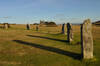
Minions and the Cheesewring

Minions and the Cheesewring
3.8 miles/6.8 km - Moderate
A circular walk around the iconic landmarks at Minions, including The Hurlers stone circles, The Cheesewring and the engine houses of the South Phoenix Mine. The route also includes the Rillaton Barrow and the Neolithic enclosure of Stowe's Pound.
-
4 miles/6.5 km - Moderate
Bowithick to Buttern Hill

Bowithick to Buttern Hill
4 miles/6.5 km - Moderate
A circular walk over the northern tip of Bodmin Moor to the prehistoric burial chamber at the top of Buttern Hill and source of the River Fowey, returning via farm tracks and country lanes to the tributary streams of the River Inny.
-
4.7 miles/7.6 km - Moderate
Cardinham and Bury Castle

Cardinham and Bury Castle
4.7 miles/7.6 km - Moderate
A circular walk in the tributary valleys of Cardinham Water to the remains of the Bury Castle hill fort where the ramparts are still over 14ft high even after more than 2000 years.
-
5 miles/8 km - Moderate
Caradon Hill to Trethevy Quoit

Caradon Hill to Trethevy Quoit
5 miles/8 km - Moderate
A circular walk in the valley of the River Seaton to the Neolithic tomb from the copper mines of Caradon Hill where the brittle ore could not be usefully crushed by machine so teenage girls were used instead to break the ore with hammers.
-
5.6 miles/9 km - Moderate
Delabole to Lanteglos

Delabole to Lanteglos
5.6 miles/9 km - Moderate
A circular walk through bluebell woodland, fields and along back lanes from Delabole to Camelford's parish church at Lanteglos, returning via the Iron Age forts of Castle Goff and Delinuth Camp.
-
6.2 miles/10 km - Moderate
East Moor and Lynher Valleys

East Moor and Lynher Valleys
6.2 miles/10 km - Moderate
A circular walk in one of the less well-known areas of Bodmin Moor to the summit of Fox Tor and through the prehistoric remains which date from the Bronze Age and Neolithic times.
-
7.1 miles/11.5 km - Moderate
Portheras Cove and Chûn Quoit
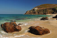
Portheras Cove and Chûn Quoit
7.1 miles/11.5 km - Moderate
A circular walk along the coast to the white, sandy beach of Portheras Cove and across the Penwith Moors to a prehistoric tomb the age of the Egyptian Pyramids
-
7.4 miles/11.8 km - Moderate
St Just to Nanquidno

St Just to Nanquidno
7.4 miles/11.8 km - Moderate
A circular walk from St Just to Cape Cornwall and the Cot Valley, where an ancient beach has been eroded from the cliffs at Porth Nanven, releasing granite boulders resembling Dinosaur eggs. The route includes Ballowall Cairn and the remnants of the Iron Age settlement at Nanjulian.
-
5.1 miles/8.2 km - Moderate-strenuous
Lamorna and St Loy

Lamorna and St Loy
5.1 miles/8.2 km - Moderate-strenuous
A circular walk visiting prehistoric stone circles, crosses and tombs and along the granite cliffs from Lamorna Cove to the sea-polished boulders of St Loy's Cove where sailors of a sinking vessel were able to climb to safety onto a large ship which had been wrecked there seven months before.
-
5.2 miles/8.4 km - Moderate-strenuous
Rough Tor and Brown Willy

Rough Tor and Brown Willy
5.2 miles/8.4 km - Moderate-strenuous
A mostly circular walk to Cornwall's two highest tors, passing prehistoric remains including the holy well, summit cairns and settlements.


Download the iWalk Cornwall app and use the QR scanner within the app to find out more about any of the walks above.
