

Polzeath beach
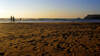
The name Polzeath comes from the Cornish words for "dry" and for "pool/harbour", perhaps because there is a beach at all stages of the tide. Down the left side of the beach, there are some good rockpools at low tide. The rest of the beach is very flat and sandy, which can make for some long rides (and paddles!) if you are surfing. This also means that in the shallows, the waves are small which makes it safer for small children to paddle or surf than some of the steeper beaches further north. The beach is patrolled by lifeguards and there is usually a separately flagged Malibu area to avoid surfers mowing down swimmers.
The tide goes out and comes in a long way so bear that in mind to avoid floating picnics. In the event of such a catastrophe or for those more inclined, there are a number of cafés around the beach and even a grocery shop. There is often an ice cream van on the beach in the summer, so parents may want to be armed with change to avoid diplomatic incidents.
Walks visiting Polzeath beach
-
3.7 miles/6 km - Easy
Polzeath to St Enodoc Church

Polzeath to St Enodoc Church
3.7 miles/6 km - Easy
A circular walk along the coast from Polzeath past a number of small coves to the vast sandy beach at Daymer Bay, returning through the dunes past St Enodoc Church which was once so deeply buried in the sand that entrance for services was through the roof.
-
5.8 miles/9.4 km - Easy-moderate
Rock to Polzeath

Rock to Polzeath
5.8 miles/9.4 km - Easy-moderate
A circular walk across the dunes and headland between Rock and Polzeath, returning via St Enodoc Church, where Sir John Betjeman is buried.
-
4.2 miles/6.7 km - Moderate
The Rumps to Polzeath around Pentire Point

The Rumps to Polzeath around Pentire Point
4.2 miles/6.7 km - Moderate
A circular walk across the Iron Age hillfort on the twin headlands of The Rumps and around Pentire Point, with panoramic views of the Camel Estuary and the offshore islands, to the sandy beach at Polzeath.
-
9.4 miles/15.1 km - Moderate-strenuous
Port Isaac to Polzeath (via bus)

Port Isaac to Polzeath (via bus)
9.4 miles/15.1 km - Moderate-strenuous
A one-way coastal walk, made circular via an initial bus journey, from Port Isaac to Polzeath along the Rollercoaster Path to Port Quin, the golden beaches of Lundy Bay via the Iron Age hillfort on the twin headland of The Rumps.


Download the iWalk Cornwall app and use the QR scanner within the app to find out more about any of the walks above.
For a walk finishing at Polzeath, the Polzeath to St Enodoc church walk is ideal. The Pentire Point walk also reaches Polzeath about half a mile from the end, so it's not too long a walk back after some time on the beach. There are also some walks further up the Camel Estuary at Rock and on the other side at Padstow.